Stage 1: Directions
 Church on the square in Chipude
 canyons and cacti
 magnificent view of the Valle Gran Rey


Directions:
The first day begins with a 23 km bus ride to the center of the island (get off after about 40 minutes at the "Pajarito" roundabout). The first bus of line 1 leaves (as of January 2015) daily at 10:30 am from the bus station in San Sebastián de la Gomera. If you arrive directly from Tenerife with the first ferry in the morning, you can usually reach this bus. If that doesn't work, there is (except Sundays) a second bus at 12:00 p.m. However, we recommend a shortened variant of the hike so that you don't arrive at the destination in the dark: get off two stations further in the village of "Chipude" instead of "Pajarito". From there you can use the normal route from waypoint 4.
Tip:
The bus station is housed in the same building as the market hall, which also houses an underground supermarket - ideal for getting provisions for the first day of hiking.
Facts about stage 1
Altitude: 180m ascent / 1450m descent
Route: 15km
Duration: 5:30h (without breaks)
Route download for stage 1 (GPX file)
All other downloads can be found at maps.
Directions/Route
The ascent to the highest point of the island, the "Alto de Garajonay", begins from the "Pajarito" roundabout. A signposted circular route leads from here to the summit and back again. We follow this circular route on the narrow and shorter path to the summit, which can be reached after about 900m from the roundabout.
We leave the viewing platform at the summit (waypoint 1) in a westerly direction and descend towards Chipude. We follow the circular path back to "Pajarito" for a short time, leaving it soon to the right (Chipude is signposted, waypoint 2). In the further course of the path there are a few junctions with signs in the direction of Chipude until we reach the small group of houses "Los Manantiales" (waypoint 3). Here we cross the courtyard in front of us and descend the steps between the houses in an S-curve over further stairs into terraced and beautifully green terrain. We follow the path, which rises a little in between in a large left turn over a hilltop and already see Chipude lying in front of us (waypoint 4).
There is an opportunity to take a break on the main square in front of the church. A small supermarket and a bar invite you to take a break.
From Chipude down to Valle Gran Rey
From the main square there is a small steep road downhill (signposted "Valle Gran Rey, 8.9 km). After a few meters we meet the main road again, which we follow briefly to the left uphill and turn right at the next opportunity (waypoint 5). Attention: at the time of our inspection there were no signposts. After a few meters we turn right again (waypoint 6). The fact that the path actually continues here between the houses is only apparent in retrospect, when the path narrows again and becomes an idyllic hiking route.
After some time we cross an unpaved road and follow the sign for "La Matanza" straight ahead and steadily downhill. In a small depression with a watercourse, our path joins another hiking trail, which also leads down into the "Valle Gran Rey" from the opposite side of the slope "El Cercado". So we follow the signpost in the direction of "Valle Gran Rey". The path runs parallel to a former water canal for long stretches and leads above a canyon-like gorge. When the valley then widens a bit, we meet the "real" circular hiking trail GR-132 (waypoint 7) for the first time at a crossroads. So far we have only been on a feeder route.
We follow the GR-132 down to the right towards "Valle Gran Rey", cross the small valley and climb up again on the opposite side. At the top of the saddle point, a phenomenal view of the "Valle Gran Rey" (waypoint 8) awaits us. At the same time, we sense that there is still a long descent ahead of us. We turn right into the path that runs along the slope, which gradually becomes steeper. At this point, hiking poles and good shoes really pay off for the first time.
Almost at the bottom of the valley we turn at a small house onto a path running parallel to the valley, which leads us to the small church "Iglesia de los Santos Reyes". Behind the church we descend stairs into the river bed, which we follow more or less directly downstream on a wider path. Soon after, we reach the destination of the first stage with "La Calera".


Stage 1: accommodation

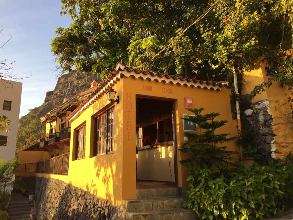
Hotel Jardin Concha
The Hotel Jardín Concha is a small, friendly hotel with simply but neatly furnished and always very clean rooms (Link: Hotel Jardin Concha). Perfect for hikers: Located almost directly on the GR-132 in the district of "La Calera" and plenty of space on the balconies and terraces to relax or dry laundry.
There is a very tasty breakfast here, which can be taken on the roof terrace in good weather.
There is a wide range of other accommodation options in Valle Gran Rey. From small pensions to 4-star hotels, everything is represented. When booking accommodation, however, you should pay close attention to the location: The municipality of "Valle Gran Rey" consists of several districts, some of which are several kilometers apart. The district "Las Hayas" (destination of stage 2) also belongs to the municipality of Valle Gran Rey, but is over 1000 meters higher than La Calera! For stage 1, the districts of La Playa, La Calera or the easily accessible accommodation Hotel Gran Rey (3 stars, higher proportion of package travelers, link: Hotel Gran Rey) or the Apartamentos Charco del Conde (apartment complex with simple but spacious rooms, pool, beach location, link: Apartments Charco del Conde).
For booking accommodation we recommend: our tabular planning aid.
Option: Two nights in Valle Gran Rey
If you want to take the circular hike on La Gomera slowly and have some time, it might be worth spending two nights in Valle Gran Rey. It is not for nothing that this part of La Gomera is the most popular holiday region on the island, numerous cafés and restaurants and a bit of hippie flair make your stay very pleasant and relaxed.
Tips for daytime activities in Valle Gran Rey:
- Bathing in the Atlantic: One of the most beautiful natural beaches of La Gomera is located at the southwest end of Valle Gran Rey behind the district "Playa de la Calera".
- Short hike to the waterfall at "El Guro": A very popular and family-friendly hike leads to the waterfall near the artist's village "El Guro", which is well worth seeing.
- demanding day hike through the rocky gorge "Barranco de Argaga": The hike described here The first part leads up through a spectacular rocky gorge, but the second part is identical to the descent into Valle Gran Rey from our stage 1. If you want, you can instead extend the hike to El Cercado or Chipude and from there take the bus back to the Valle Drive Gran Rey (currently daily except Sundays with line 1, Note the bus timetable).
